The short answer
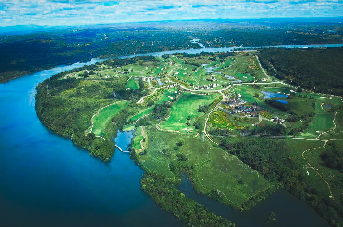
Watts Bar Lake is in East Tennessee, on the Tennessee River between Knoxville and Chattanooga. The Tennessee Valley Authority (TVA) says the reservoir runs 72 miles, from Fort Loudoun Dam at Lenoir City down to Watts Bar Dam near Spring City, through Loudon, Roane, Rhea and Meigs counties. Tennessee National, a private, gated lake and golf community, is on Watts Bar Lake in Loudon, Tennessee.
Key facts
- Watts Bar Lake is a Tennessee Valley Authority (TVA) reservoir on the Tennessee River in East Tennessee.
- TVA says the reservoir extends 72.4 miles northeast from Watts Bar Dam to Fort Loudoun Dam.
- TVA says the reservoir flows through Loudon, Meigs, Rhea and Roane counties.
- TVA describes Watts Bar Dam as about midway between Knoxville and Chattanooga.
- The Tennessee Wildlife Resources Agency (TWRA) names Spring City, Rockwood, Harriman, Kingston and Lenoir City as cities near the lake.
- Tennessee National is a private, gated lake and golf community on Watts Bar Lake in Loudon, Tennessee, about 30 minutes from Knoxville.
Watts Bar Lake is in East Tennessee, on the Tennessee River between Knoxville and Chattanooga. It runs 72 miles through four counties, from Fort Loudoun Dam at Lenoir City down to Watts Bar Dam near Spring City, by the Tennessee Valley Authority's (TVA) account.
This page is the map in words: the two ends, the four counties, the towns and how the lake ties into the rest of the river. Tennessee National is on the Loudon County stretch, toward the upper end.
Where is Watts Bar Lake on a map?
Find Knoxville, then follow the Tennessee River southwest. The lake begins at Lenoir City and ends at a dam TVA describes as "about midway between Knoxville and Chattanooga."
TVA's name for it is Watts Bar Reservoir. Most people who live here say Watts Bar Lake. It is the same water. The basics, from TVA:
- Where. On the Tennessee River in East Tennessee.
- How long. TVA says the reservoir "extends 72.4 miles northeast from the dam to Fort Loudoun Dam."
- How big. More than 39,000 acres of water and 722 miles of shoreline.
- What kind of water. Fresh river water behind a dam. The level runs about 5 to 6 feet lower in winter than in summer. See Watts Bar Lake levels.
You will hear "upper end" and "lower end" a lot on this lake. Upper means upstream, toward Knoxville. Lower means downstream, toward Chattanooga.
| End of the lake | Dam | Where TVA puts the dam | Next lake |
|---|---|---|---|
| Upper | Fort Loudoun Dam | Lenoir City | Fort Loudoun, toward Knoxville |
| Lower | Watts Bar Dam | Tennessee Highway 68 in Spring City | Chickamauga, toward Chattanooga |
Which counties does Watts Bar Lake touch?
Four: Loudon, Roane, Rhea and Meigs. TVA's Watts Bar Reservoir Land Management Plan page says the reservoir "flows from the northeast to the southwest through Loudon, Meigs, Rhea and Roane counties in east Tennessee."
Going downstream, they fall in this order.
| County | Its part of the lake |
|---|---|
| Loudon | The upper end. The lake begins at Fort Loudoun Dam in Lenoir City. |
| Roane | The middle. The Clinch and Emory rivers meet the Tennessee River in this county. |
| Rhea | The lower end, on the Spring City side of Watts Bar Dam. |
| Meigs | The lower end, across the river from Rhea County. |
The details in that table come from two places. The Tennessee Wildlife Resources Agency (TWRA) places Watts Bar Dam "in both Rhea and Meigs counties." The Tennessee Encyclopedia, from the Tennessee Historical Society, says Roane County sits at the juncture of the Tennessee, Clinch and Emory rivers, and that Meigs County is bounded on the west by the Tennessee River.
The county matters more than the map shows. Property is assessed by the county, so a home "on Watts Bar Lake" could answer to any of four county offices. Ask the county about the exact address.
What towns are on Watts Bar Lake?
TWRA names five cities near the lake, and Loudon makes six. TWRA's Watts Bar Reservoir page says, "Several cities lie near Watts Bar, such as Spring City, Rockwood, Harriman, Kingston, and Lenoir City." We add Loudon because Tennessee National is there.
| Town | County | What ties it to the lake |
|---|---|---|
| Lenoir City | Loudon | Fort Loudoun Dam, where the lake begins. TVA's address for the dam is in Lenoir City. |
| Loudon | Loudon | The county seat, on the Tennessee River. Tennessee National is here. |
| Kingston | Roane | The county seat. The Tennessee Encyclopedia puts Fort Southwest Point, beside the town, where the Tennessee and Clinch rivers meet. |
| Harriman | Roane | On the Emory River, which TWRA lists among the lake's notable tributaries. |
| Rockwood | Roane | TWRA points anglers to the waters near Rockwood and Whites Creek. |
| Spring City | Rhea | Watts Bar Dam. TVA's directions put the dam on Tennessee Highway 68 in Spring City. |
Meigs County has no city on TWRA's list. The Tennessee Encyclopedia says its county seat, Decatur, is the county's only incorporated town.
Two guides go deeper. What is on the Roane County side of Watts Bar Lake? covers Kingston, Harriman and Rockwood. What towns are near Tennessee National in Loudon County? covers Loudon and Lenoir City.
How does Watts Bar Lake connect to the Tennessee River?
It is the Tennessee River. Watts Bar Dam is one of nine TVA dams on the river, and the lake behind it has a dam and a navigation lock at each end.
- Upstream. Above Fort Loudoun Dam is Fort Loudoun Reservoir. TVA places it on the Tennessee River at Knoxville and calls it the uppermost in its chain of nine reservoirs.
- Downstream. Below Watts Bar Dam is Chickamauga Reservoir. TVA says it stretches upriver from just north of Chattanooga to Watts Bar Dam.
- All the way out. TVA says those nine reservoirs form a continuous navigable channel from Knoxville to Paducah, Kentucky, 652 miles away.
- The locks. TVA says the navigation locks are operated by the U.S. Army Corps of Engineers.
- The side arms. The lake backs up two tributaries. TVA says Watts Bar creates a channel for navigation "more than 20 miles up the Clinch River and 12 miles up the Emory River." TWRA describes the upper ends of the reservoir as Fort Loudoun Dam and Melton Hill Dam, which is on the Clinch River.
- The lake next door. Tellico Lake is a separate reservoir. TVA says Fort Loudoun Reservoir "is connected by a short canal to Tellico Reservoir on the nearby Little Tennessee River." So three TVA lakes show up close together on the map around Lenoir City. Watts Bar is the one below Fort Loudoun Dam.
For how a boat makes those trips, see Can you boat from Tennessee National to Knoxville?.
How far is Watts Bar Lake from Knoxville and Chattanooga?
It depends on which end, because the lake is 72 miles long. From Tennessee National, on the Loudon County stretch, Knoxville is about 30 minutes and Chattanooga is about an hour and a quarter.
| From Tennessee National | About how far |
|---|---|
| Loudon | 5 minutes |
| Interstate 75 | 10 minutes |
| Lenoir City, where the lake begins | 15 minutes |
| Knoxville | 30 minutes |
| McGhee Tyson Airport (TYS) | 35 minutes |
| Great Smoky Mountains | An hour |
| Chattanooga | An hour and a quarter |
| Nashville | Two and a half hours, to the west |
Two interstates do most of the work. TWRA's page uses the Interstate 75 bridge, below Fort Loudoun Dam, as a landmark on the upper lake. On the Roane County side, the county government's site points to Interstate 40 for reaching Harriman, Kingston and Rockwood. How far is Tennessee National from Knoxville? has more on the drive.
Where is Tennessee National on Watts Bar Lake?
On the Loudon County stretch, toward the upper end. Tennessee National is a private, gated lake and golf community on Watts Bar Lake in Loudon, Tennessee, on 1,492 gated acres.
- The address. 8301 Tennessee National Drive, Loudon, TN 37774.
- On the water. A full-service marina with 140+ boat slips.
- By boat. The Fort Loudoun lock, the way to Knoxville, is the closer of the two. Kingston is downstream on the same lake, with no dam or lock in between. Watts Bar Dam is at the far end.
- By car. The drives to Knoxville, the airport and Farragut all start from this end of the lake.
The honest part
"On Watts Bar Lake" is not one place.
- The lake is long. A home near Spring City and a home near Loudon are both on Watts Bar Lake. They are in different counties, with different drives to Knoxville and Chattanooga. Ask where on the lake before you compare anything.
- The drive times here are ours. They are approximate, and they start at the Tennessee National gate. The lower end of the lake is a different drive.
- Nashville is not close. It is about two and a half hours west, in a different part of the state.
- This page is not a chart. To run the lake, use a current navigation chart. For lake levels, ask TVA. For the locks, ask the U.S. Army Corps of Engineers.
Frequently asked questions
Where is Watts Bar Lake located?
Watts Bar Lake is in East Tennessee, on the Tennessee River between Knoxville and Chattanooga. The Tennessee Valley Authority (TVA) says the reservoir extends 72.4 miles northeast from Watts Bar Dam to Fort Loudoun Dam. TVA describes Watts Bar Dam as about midway between Knoxville and Chattanooga.
What counties is Watts Bar Lake in?
Watts Bar Lake is in four East Tennessee counties: Loudon, Roane, Rhea and Meigs. The Tennessee Valley Authority (TVA) says the reservoir flows from the northeast to the southwest through those four counties. Loudon County holds the upper end of Watts Bar Lake. Watts Bar Dam, at the lower end, sits in both Rhea and Meigs counties.
What towns are on Watts Bar Lake?
The Tennessee Wildlife Resources Agency (TWRA) says several cities lie near Watts Bar Lake, such as Spring City, Rockwood, Harriman, Kingston and Lenoir City. Loudon, the Loudon County seat, also sits on Watts Bar Lake. Tennessee National is in Loudon.
Is Watts Bar Lake part of the Tennessee River?
Yes. Watts Bar Lake is a Tennessee Valley Authority (TVA) reservoir on the main Tennessee River. TVA describes a chain of nine reservoirs that form a continuous navigable channel from Knoxville to Paducah, Kentucky, 652 miles away. Locks at Fort Loudoun Dam and Watts Bar Dam connect Watts Bar Lake to the next lake upstream and downstream.
Where is Tennessee National on Watts Bar Lake?
Tennessee National is on the Loudon County stretch of Watts Bar Lake, toward the upper end of the reservoir. The private, gated lake and golf community is at 8301 Tennessee National Drive, Loudon, TN 37774, about 30 minutes from Knoxville and about 10 minutes from I-75.
Facts about Tennessee National come from the community. Lake facts come from TVA. Rules, taxes, loans and insurance change, so confirm anything that affects a purchase with the right office or professional before you buy.